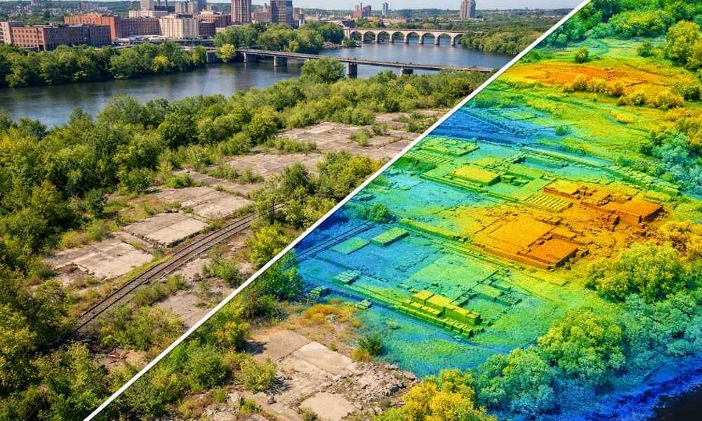
Old industrial sites hide their history in the dirt. A mill floor gets torn out, but the pad underneath stays. A rail spur gets pulled up, but the grade it sat on doesn’t disappear. Along the riverfront, where mills, lumberyards, and rail lines ran for over a century, this kind of buried history sits under brush and weeds on more parcels than most people realize.
Lidar mapping gives redevelopment teams a way to see that history before shovels hit the ground. It’s a laser-based method that measures the ground surface in fine detail, even where a person can’t walk. For riverfront cleanup planning, that detail matters. Here’s how it works on sites with old industrial features.
Reading Micro-Topography: How LiDAR Exposes Buried Foundations and Slab Lines
A lidar scan doesn’t just draw a flat map. It builds a bare-earth model that shows small bumps, dips, and grade breaks across a site. Those small changes often line up with things that used to be there. An old building pad leaves a slight rise. A demolished slab leaves a flat shelf where the ground should slope. A loading dock leaves a short, sharp drop.
None of these clues are obvious on a walk-through, especially on a site that’s been empty for decades. A person walking the ground sees weeds and uneven dirt. A lidar model shows the pattern underneath. That pattern gives engineers a starting point for where to dig test pits or run soil borings, instead of guessing across the whole parcel.
Bare-Earth Filtering: Seeing Through Overgrowth on Long-Vacant Industrial Parcels
Old industrial land near the Mississippi River often sits idle for years. Brush grows fast. Trees take root in old rail beds. By the time a redevelopment team looks at the site, half of it is hidden under green.
Lidar sensors send out thousands of laser pulses per second. Some of those pulses hit leaves and branches. Others slip through gaps in the canopy and hit the actual ground. Classification software sorts out which points came from vegetation and which came from bare earth, then builds a ground surface model using only the real dirt points. The result is a clean picture of the land underneath the brush, without cutting down a single tree first.
Grading Fingerprints: Old Rail Spurs, Retaining Walls, and Fill Patterns
Rail-served mills and warehouses left a specific kind of mark on the land. Spur lines needed flat, graded beds. Loading areas needed retaining walls to hold back higher ground. Fill got dumped in low spots to level out yards.
These features show up as long, straight or gently curved lines in a lidar-based contour map, running in directions that don’t match the current property lines or roads. A surveyor looking at that pattern can often tell where a spur used to run or where an old retaining wall held soil in place, long before any of it shows up in a site walk. That’s useful information to flag for the environmental and design teams before they lock in a site plan.
Volumetric Tracking Across Cleanup Phases: Measuring Cut, Fill, and Cap Placement
Cleanup work on old industrial land usually happens in stages. Soil gets removed in one phase. Clean fill or a cap gets placed in another. Grading gets finished later.
Each time a site gets flown with lidar, that flight becomes a snapshot of the ground surface at that point in time. Compare two snapshots, and engineers can calculate exactly how much soil moved between them, in cubic yards, not estimates. That number matters for tracking how much contaminated material actually left the site and how much clean material came in to replace it. Project managers get a real record for each phase instead of relying on notes and memory once the work is done.
Layering LiDAR Point Clouds Over Historic Sanborn and Plat Maps
A current lidar model tells you what the ground looks like today. Old Sanborn fire insurance maps and historic plats tell you what stood there fifty or a hundred years ago. Put the two together, and a redevelopment team can line up an old building footprint, tank location, or rail alignment against the current property lines with real accuracy.
This step is worth doing early, before a Phase I or Phase II Environmental Site Assessment starts. It gives the environmental consultant a shortlist of specific spots to check, based on what actually sat on the land, rather than testing the whole parcel at the same level of detail. On riverfront parcels with a long industrial history, this kind of layered research often turns up more than a quick title search or aerial photo review would catch alone.
FAQ
Can LiDAR detect underground contamination or old fuel tanks directly?
No. Lidar reads the surface and near-surface ground. It can’t see through the soil. What it can do is point out surface clues, like grade changes or old pads, that tell an environmental team where to dig or test. Confirming contamination or a buried tank still takes a Phase I or Phase II Environmental Site Assessment, soil borings, or a tool like ground-penetrating radar.
How is LiDAR different from a standard topographic survey for a redevelopment site?
A standard topo survey collects ground shots at specific points a crew can walk to and set up on. Lidar collects a dense, continuous model of the entire surface, including spots crews can’t easily reach on foot. On an overgrown industrial parcel, that difference means a lot more usable ground data.
Do I still need a licensed surveyor if I already have LiDAR data?
Yes. Lidar collects data. A licensed land surveyor controls that data, ties it to real property boundaries, and certifies it for anything tied to a title survey, permit, or legal description.
How often should a riverfront cleanup site be re-flown with LiDAR?
It depends on how fast the work moves, but many cleanup projects fly again after each major earthwork phase, initial cut, soil removal, and cap or fill placement, so each stage has its own record instead of just a before-and-after comparison.
Can LiDAR mapping speed up permitting for riverfront redevelopment projects?
It can help by giving reviewers a clear, accurate picture of existing site conditions early on, which cuts down on back-and-forth over basic site data. It doesn’t replace any required environmental, floodplain, or zoning approval specific to riverfront land.