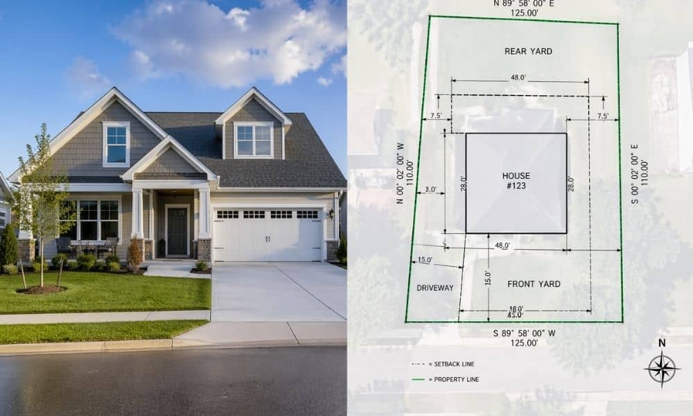
Online property listings make homes look simple. Clean photos. Nice rooms. Green yards. Clear price. It all feels complete at first glance. But a house survey tells a different story. It shows the real layout of the land and home, not just the polished version you see online.
Many buyers in places like Minneapolis rely on listings to understand what they are getting. That works only on the surface. Once a house survey comes into the picture, small details start to change how the property actually looks and feels.
Listings show appearance, not measurement
Online listings focus on visuals. They show how a home looks, not how it is measured on the ground. That gap creates confusion for many buyers.
A house might look centered on a lot in photos. The yard might look wide and even. The driveway might seem fully inside the property. However, listings do not confirm any of that with exact data.
You start to notice the difference when you see what a house survey actually shows. It shows how the home and land are actually laid out, not just how they appear in pictures. That is usually when small details stand out. A fence may sit closer to a boundary than expected. A garage might sit a bit off from where it looked online. Even small shifts matter when space is limited.
Because of that, buyers often realize the listing only tells part of the story.
Property boundaries are rarely clear online
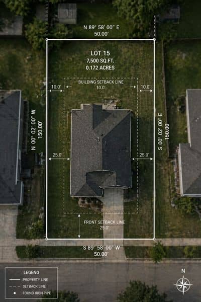
Most online listings avoid detailed boundary information. They focus on square footage inside the home. They rarely show where the land begins and ends with precision.
A house survey clears this up. It maps the exact property lines using measurements from the ground. This matters because land does not always follow what people assume from fences or landscaping.
In many cases, a fence does not sit on the legal boundary. A shed might sit partly on neighboring land. A driveway might cross a small section of another parcel without anyone noticing.
These details do not appear in listing photos. They only appear when a house survey is completed.
So while listings show “ownership space” in general terms, surveys show ownership in exact terms.
The shape of the land often surprises buyers
Land shape is another detail listings do not explain well. Most buyers see a flat rectangle in their mind. That image comes from photos and simple diagrams.
Reality often looks different.
A house survey shows the real shape of the lot. Some properties narrow at the back. Some angle slightly to one side. Some include uneven edges that change how usable space feels.
This matters when planning future use of the property. A yard that looks large online may feel smaller once measurements appear. A space that looks perfect for expansion may not support it once the true layout becomes clear.
Because of this, the house survey often resets expectations.
Plans for improvements often change after a survey
Many buyers think about future changes when they view listings. They picture decks, garages, extensions, or gardens. That planning usually comes from what they see online.
However, once a house survey is done, those plans often shift.
A space that looked open might have limits that were not obvious. A section of yard might not support the building due to shape or position. Even small measurement differences can change what fits and what does not.
This is where the gap between listing and reality becomes clear. Listings support imagination. A house survey supports decisions.
So buyers adjust plans once they see the real layout on paper.
Older city areas add more uncertainty
Cities like Minneapolis often have older neighborhoods with layered property histories. Many homes sit on land that has changed shape or use over time.
Online listings do not show this history. They present a clean, current snapshot.
A house survey brings clarity back into the picture. It shows how the property sits today, not how it was assumed years ago. It also helps reveal mismatches between older assumptions and current conditions.
This matters because land records and real-world conditions do not always match perfectly in older areas. Even small shifts in layout can create confusion for buyers who rely only on listing data.
So the house survey becomes a way to confirm what the land actually looks like now.
Why listings cannot replace real measurements
Online listings serve one main purpose. They help properties sell. They are not built to show technical details with full accuracy.
Because of that, a lot of important land information gets simplified or left out. What you see is usually a cleaned-up version that’s easy to scan and understand quickly.
A house survey fills that gap. It’s based on real measurements taken on the site, not just photos or descriptions.
That’s usually when buyers start to look at things differently, especially before trusting online property listings on their own. Once the actual measurements come in, the layout doesn’t always match what the photos suggested. Something that looked centered might not be. A space that looks open can feel tighter in reality.
At that point, things start to make more sense once you’re looking at the actual land instead of the listing.
What a house survey gives that listings never can
A house survey gives a clear picture of the property as it exists on the ground. It does not interpret or simplify. It measures.
Buyers gain clarity in several ways. They see how the home sits on the land. They understand how space actually spreads across the lot. They also get a better sense of how usable the property really is.
That information does not appear in listings because listings are not built for that purpose.
Once buyers compare both, the difference becomes obvious. Listings show the idea of a property. A house survey shows the physical reality of it.
Final thought
Online property listings help people discover homes. They create interest and guide first impressions. But they do not show the full picture.
A house survey fills in what listings leave out. It replaces assumptions with measurements. It turns a visual impression into clear land data.
When buyers understand that difference, they make decisions with more confidence. They no longer rely only on what looks good online. They rely on what actually exists on the ground.